Unit 1 · Introduction to Geography · Lesson 1.3 The Map Case · one idea at a time
We'll take this one idea at a time
Cartographer's Studio
Satellites help. Computers help. A person still makes the map. Cartography jumped in sudden leaps, especially in the 1400s–1500s and in the 1900s. Your study sheet is a table of nine mapmakers with dates. Learn the names and dates here. Fill the notes and sketches from Apex's timeline, then check the sample responses.
Explain that humans still make maps, even with satellites and computers.
Name the two periods the lesson flags as big leaps: the 15th–16th century age of exploration, and the 20th-century technology boom.
Match the nine study-sheet cartographers to their dates.
No rush. Next brings the next idea. Back always works. Your place is saved here.
If you want it
A running start
The last two studies were about flattening globes and stretching Greenland. This one is a table of names. Open this if that shift feels like a new course.
Not sure about the basics underneath this lesson?
A satellite can take a picture. A person still decides what the map will show. Your notebook wants nine names and nine dates. This hub will drill those matches. The pop-up notes and sketches live in Apex; we did not capture them, so we will not invent them.
1
Two jump periods
15th–16th century age of exploration, and 20th-century technology. Cartography did not improve in a tiny drip every year.
2
Two names you already know
Mercator 1569 (cylindrical stretch). Robinson 1963 (compromise oval). That is 1.3.1 wearing dates.
3
Fill the rest in Apex
Open the timeline, write the notes, sketch, then check sample responses. Use this hub to lock the dates.
Quick check — answer out loud before you peek
Does a satellite 'make' a map in this lesson's sense?
No. Satellites help. A human being still makes every map.
When this makes sense, hide it and go back to the lesson.
You can skip this and come back. Next goes into the lesson.
Lesson 1.3.3 p11 of 3 in this idea
A person still makes the map
You have already seen aerial photos and satellites. They matter. They do not press 'print' on a finished map. The lesson's line: every map that has ever existed was made by a human being.
Lesson 1.3.3 p12 of 3 in this idea
A person still makes the map
This activity has two halves. First, a history of people who pushed cartography forward. Then a look at a present-day studio, including interviews with people who still work with maps: an Antarctic cartographer, a road-map collector, and a GIS scientist (Dr. David M. Theobald).
Lesson 1.3.3 p13 of 3 in this idea
A person still makes the map
Computers and databases are the current trend for showing spatial information. Hand-drawn maps are still being made and used. Making a picture of the world is a creative act either way.
0
If a question says satellites now make maps by themselves, it is wrong. Humans are still essential.
Lesson 1.3.3 p21 of 2 in this idea
Leaps, not a slow drip
Cartography did not improve in a steady trickle. It jumped. The lesson names two clusters of leaps: • The age of exploration in the 15th and 16th centuries • The technological boom of the 20th century
Lesson 1.3.3 p22 of 2 in this idea
Leaps, not a slow drip
Page 4's review is titled "The Making of the Modern-Day Map" and starts from "the collection of fact-based observations." That interactive was not captured. The idea you can still use: maps got less distorted as people collected better observations (the same accuracy factors you met in 1.3.4).
0
Two leap windows: 1400s–1500s exploration, and the 1900s tech boom. Not 'a little better every year since year 1.'
Lesson 1.3.3 study sheet1 of 3 in this idea
Nine names, nine dates
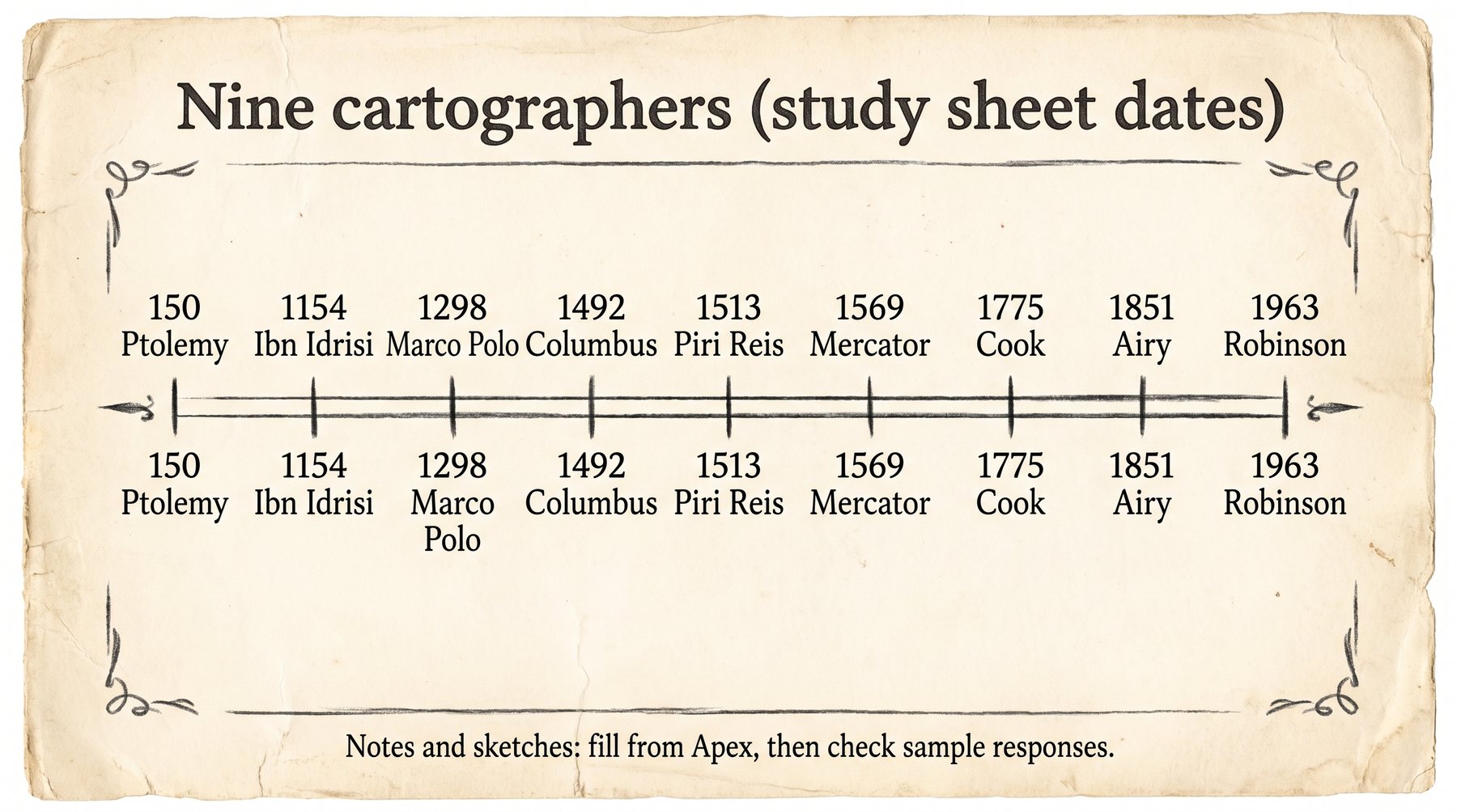
Your notebook table has nine rows. The course gives you the names and dates. Learn these matches. The timeline pop-ups that held the notes and sketches were not captured in the library, so this hub will not fake those sentences. Fill Notes and Sketch from Apex, then check the sample responses.
Lesson 1.3.3 study sheet2 of 3 in this idea
Nine names, nine dates
Ptolemy — 150 Abu Abdullah Ibn Idrisi — 1154 Marco Polo — 1298 Christopher Columbus — 1492 Piri Reis — 1513 (Apex gives him a review screen of his own) Gerardus Mercator — 1569 James Cook — 1775 Sir George Biddell Airy — 1851 Arthur Robinson — 1963
Lesson 1.3.3 study sheet3 of 3 in this idea
Nine names, nine dates
Two you already have notes for from 1.3.1: Mercator is the cylindrical stretch (Greenland looks huge). Robinson is the compromise oval that distorts a little of everything.
The study sheet's nine dates. Notes and sketches still come from Apex's timeline.
Click a diagram to open it bigger.
A quiz in this section may ask you to match a name to a date. Mercator 1569 and Robinson 1963 are the ones already tied to projection families you studied.
Not sure about this bit?
Say them in order. The years are the testable part this hub can stand behind.
1
Ancient to medieval
Ptolemy 150. Ibn Idrisi 1154. Marco Polo 1298.
2
Exploration leap
Columbus 1492. Piri Reis 1513. Mercator 1569.
3
Later
Cook 1775. Airy 1851. Robinson 1963.
Quick check — answer out loud before you peek
Mercator? Robinson? Piri Reis?
1569. 1963. 1513.
When this makes sense, hide it and go back to the lesson.
Lesson 1.3.3 p51 of 2 in this idea
People still do this for a living
Mapmaking did not stop in the 20th century. Apex sends you to three interviews: • Brad Herried, Antarctic cartographer (Polar Geospatial Center): mapping Earth's most remote continent • A road-map collector: maps for pleasure • Dr. David M. Theobald on GIS: how he started, GIS in education, GIS for conservation
Lesson 1.3.3 p52 of 2 in this idea
People still do this for a living
That last interview is the bridge into 1.3.6. The studio now is often a computer. The job is still a person deciding what the picture should show.
0
Present-day cartography uses computers and databases and still includes hand-drawn maps. GIS is coming next, not instead of people.
That's the lesson
Before you quiz yourself
Check the ones that make sense now. This list is saved in this browser. The other tools (name that term, flashcards, practice quiz) are up top whenever you want them.
Built from Apex 1.3.3 (6 pages) and its study-sheet table of names and dates. The Cartography Timeline, Piri Reis review, and 'Making of the Modern-Day Map' interactives were not captured. This hub will not invent those pop-up notes. Mercator and Robinson notes reuse what 1.3.1 already taught.